


Quiet Hurricane Season Takes a Turn as Isaias and Rachel Threaten U.S. Coasts
After months of relative calm, hurricane season apparently decided October needed a Halloween-style plot twist.
2026 has been an exceptionally quiet year for Atlantic hurricanes.
As of September 23, only six tropical storms had formed, and none had strengthened into hurricanes. A strengthening El Niño, a naturally occurring climate pattern, has helped suppress the development of Atlantic storms.
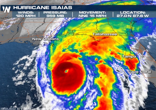
But the quiet hurricane season may be ending. Hurricane Isaias recently formed over warm waters off Mexico’s eastern coast, intensified into the Atlantic season’s first hurricane, and will hit the U.S. Gulf Coast.
Hurricane Isaias has strengthened into a major Category 3 hurricane as it approaches the northern Gulf Coast, with forecasters warning that damaging winds could bring down trees and power lines across Central Alabama overnight Friday into Saturday.
The National Hurricane Center confirmed at 7:20 a.m. Friday that Isaias had reached maximum sustained winds of 120 mph, making it a Category 3 hurricane. The storm was located approximately 240 miles south of Pensacola, Florida, moving north-northeast at 15 mph.
The National Weather Service in Birmingham is warning that wind gusts of 50 to 60 mph or higher could affect much of Central Alabama, potentially causing widespread power outages, blocked roads and significant tree damage.
#Isaias is the first major hurricane of the season. Winds are at 120mph. It could briefly strengthen more but we can already see shear getting to it & it may get worse for it as it nears the coast. Still, we expect a significant hurricane onshore. #tropicswx pic.twitter.com/3zVji8j3mZ
— Vortix (@VortixWx) October 9, 2026
With less than two months remaining in the 2026 hurricane season, Tropical Storm Isaias has formed in the Gulf. It's expected to strengthen rapidly and become a hurricane by Thursday and approach the U.S. northern Gulf Coast on Friday, the National Hurricane Center said.…
— CBS News (@CBSNews) October 7, 2026
Projections indicate a large portion of this country may be impacted by Isaias.
Some longer-range forecast models also see this moisture eventually reaching the Ohio Valley and Northeast by midweek next week.
The hurricane center on Thursday warned of “an increasing risk of dangerous wind and storm surge impacts” along parts of the northern Gulf Coast and urged people living in Louisiana, Alabama, Mississippi and northern Florida to “closely monitor the latest forecast updates and ensure they have their hurricane plan in place.” At high tide, the approximately 300-mile stretch between Ocean Springs, Mississippi, and Indian Pass, Florida, could see a storm surge of up to 7 feet, forecasters said, potentially causing major flooding.
In addition to rain, the hurricane center said Isaias could potentially bring urban flooding and isolated river flooding to places in its path.
Florida Gov. Ron DeSantis on Tuesday signed an executive order declaring a state of emergency for 25 Florida counties ahead of the storm’s arrival. DeSantis said in a statement that the order “ensures communities have the time and resources necessary to prepare for potential severe weather impacts to the Panhandle and Big Bend region of Florida.”
Big blow up of storms!
Heading into evening hours across the Gulf bath tub waters, Tropical Storm Isaias has "blown up" with thunderstorms over the center.
This explosion of convection –> soon upgrade to hurricane undergoing rapid intensification. pic.twitter.com/kCeBGoYItZ
— Ryan Maue (@RyanWeather) October 7, 2026
But why should Florida and Louisiana have all the hurricane fun? In the Pacific, Hurricane Rachel has just taken a sharp turn toward Southern California, and forecasters say it could arrive early Sunday as a weaker, post-tropical storm.
My hometown is now in the path.
The current forecast shows it coming ashore about 100 miles south of San Diego, but the path could shift as far north as Orange County.
Residents in Southern California and the desert communities should start watching for updates, forecasters said.
The National Weather Service says a large weather system moving in from the northwest will push Rachel off course.
“This will cause Rachel to slow down and then turn and accelerate toward Baja California and southern California,” the agency said in its latest advisory.
Hurricane Preparedness in San Diego! pic.twitter.com/4qm08FuWFZ
— Leslie Eastman ☥ (@Mutnodjmet) October 8, 2026
Rachel’s biggest impacts will likely be rip currents and flash floods.
Another hurricane swell is expected to bring elevated surf and strong rip currents to Southern California beaches through the end of the week, forecasters say.
As Hurricane Rachel churns off the coast of Mexico, the National Weather Service has issued beach hazard warnings and coastal flood advisories for Los Angeles, Ventura, Orange and San Diego counties, with forecasters warning of life-threatening rip currents and surf reaching 5 feet to 6 feet in some areas.
Hurricane Rachel will be "post-tropical" by time it impacts far Southern California and Arizona.
However, the remnants of Rachel will still be impactful with heavy rain and gusty winds. So, pretty much like a tropical storm but not officially.
Phoenix weather –> wild! pic.twitter.com/NCl9zBeOZD
— Ryan Maue (@RyanWeather) October 7, 2026
The rains will bring much-needed relief from the “heat dome” that has covered the region for the last few days.
Fourteen records were broken across Los Angeles, Ventura, Santa Barbara and San Luis Obispo counties, according to the National Weather Service in Los Angeles. Among the notable record highs were 104 degrees in downtown Los Angeles, 104 degrees at Long Beach Airport, 102 degrees at Hollywood Burbank Airport and 106 degrees in Woodland Hills.
Monday also marked the fourth consecutive day of triple-digit temperatures in downtown Los Angeles, a record for October. The Weather Service said that streak is likely to continue for another day or two.
Eight more record high temperatures were broken or tied in Orange and San Diego counties on Monday…
After months of relative calm, hurricane season apparently decided October needed a Halloween-style plot twist.
This development should really work up climate cultists into a frenzy.
Here in San Diego, I was hoping autumn would bring relief from the heat and some fall colors in our mountains. The upside is that the waves should be good for boogie boarding, as long as I stay out of the rip currents.
Donations tax deductible
to the full extent allowed by law.






Comments
Isaias now looking like it’s gonna more/less make landfall a little east of Pensacola and head north then a little west kinda parallel to I-65 towards Tuscaloosa then turn back the North/East. I’m basically center mass of this thing about 80 miles from the coast. Got my hurricane prep completed. Hopefully landfall weakens it but spin off tornado are definitely a worry. Most of those will be to east towards Dothan and extending into Georgia.
I haven’t read the name Dothan in many years. I remember an air base there as well as a traffic circle. Ancient history I guess. There used to be a town called Slocumb just sw of there. Maybe gone as well, it has been so long.
Dothan and Marianna are nice little border town neighbors.
Both are still there. Ft Rucker is the Army Aviation Center training helicopter pilots.
Call it “Izzy.” There’s no gain in trying to figure it out.
Izzy and Rachel! It’s those Jooish hurricanes again…!
There are hurricanes and then there are hurricanes.
Eh, we’re going to get gusts and a bit of rain in Slidell, and the only concern is the storm surge.
Yet another weekend where I won’t be able to mow my damn lawn.
Lo, the poor coasts
Yeah, It’s a damn shame that the “finger” leading down to Venice, LA is all but gone and land around Breton Sound is just as bad.