


Himalayan Landslide Triggers Catastrophic Flood at Nepal-Tibet Border
A torrent of mud, rocks and water through communities, leaving a trail of destroyed homes, roads, bridges and power infrastructure. Over 40 Americans are among the hundreds dead or missing.
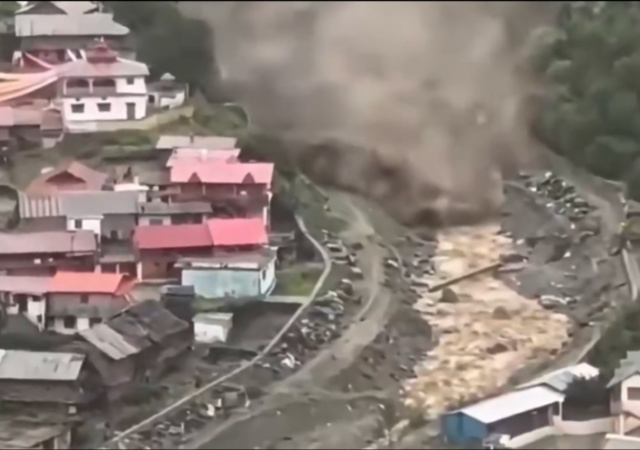
A catastrophic wall of mud, rock, and floodwater has turned a remote Himalayan border region into a disaster zone.
In Nepal’s Rasuwa district and across the border in Tibet, a massive landslide swept away entire settlements, roads, vehicles, and power infrastructure.
In a still-unfolding disaster, verified videos showed dozens of people swept away at the border, with authorities on both sides fearing far higher casualties and massive destruction.
Houses, roads and power projects were washed away in Nepal, while officials in Tibet said they feared “major casualties” after a mudslide hit a border land crossing in the county of Gyirong.
“It was a huge gush of mud coming straight towards us. As it got closer, it kept rising higher and higher. When I saw it enter our home, I tried to grab my wife’s hand and take her to the terrace. But she was swept away by the mud,” said Keshav Prasad Baral, a 68-year-old survivor, who was being treated at a small hospital.
“Four or five hours later, a helicopter came to rescue me. My wife is still somewhere beneath the mud. She’s gone.”
BREAKING: Massive mudslide from Nepal caused “major casualties” and left people missing at Gyirong Port in Tibet, Chinese state media reported. Footage appears to show people running for their lives. pic.twitter.com/D4M0Ll1WDE
— Insider Paper (@TheInsiderPaper) August 26, 2026
According to the U.S. Geological Survey, the event was initially identified as a magnitude 4.4 earthquake. Further analysis of long-period seismic waves showed that it was actually caused by a glacial collapse and debris flow. Scientists estimated the event’s location using satellite imagery.
🔴 Les images en provenance du #Népal sont terrifiantes. Le séisme d’une magnitude de 4,4 qui s’est produit la nuit dernière au Tibet a déclenché des #avalanches de glace et des #glissements de terrain. Ils ont formé des embâcles sur les rivières de la région qui ont fini par… pic.twitter.com/XIdlQ76gii
— Guillaume Woznica (@GWoznica) August 26, 2026
Essentially, the landslide looks to have temporarily created a dam…which then broke, causing the massive flash flood.
Nepal’s disaster authority (NDRRMA) described that a chunk of snow and rock broke off near the glacier zone on the Nepal-China border, about 20km northeast of the Rasuwagadhi border crossing.
That avalanche either fell into a glacial lake or blocked the river channel, and the resulting surge, carrying glacial ice, meltwater and debris — “glacier-inclusive flood” — swept down the Lhende Khola into the Bhote Koshi river.
Planet Labs को स्याटेलाइट तस्बिरको विश्लेषणका आधारमा गरिएको प्रारम्भिक अध्ययनबाट नेपाल-चीन रसुवागढी नाकाबाट करिब २० किलोमिटर उत्तरपूर्व नेपाल-चीन सिमानामा गएको हिम-चट्टान पहिरोका कारण ल्हेन्दे खोलामा गेग्य्रानसहितको बाढी आएको देखिएको छ। pic.twitter.com/kCAo9O1Zb0
— NDRRMA (@NDRRMA_Nepal) August 26, 2026
Hundreds are missing, including over 40 Americans.
Sunil Sharma, a tourism board spokesperson, said 133 were from India on pilgrimage to Mount Kailash in Tibet, a sacred site for Hindus. Also missing were 47 from the United States, 34 from Australia, 33 from Britain and 24 from Canada, he said. How many local people were also missing was not clear.
A State Department spokesperson said it “is aware of Americans impacted by the floods in Nepal and is closely tracking the situation.”
The region lies on a popular route to Kailash Manasarovar in Tibet, a site visited annually by hundreds of Hindu pilgrims from India and elsewhere, particularly at this time of year.
The landslide also impacted Tibet and triggered alerts in northern India.
The disaster also affected China’s Tibet region, where officials reported three deaths and 265 people missing in Gyirong.
The mudslide struck the Gyirong border port, damaging roads, communications and power connections. China deployed drones to assess the damage and prepared aircraft and helicopters for rescue operations.
The flooding also prompted alerts in northern India, where authorities evacuated thousands of people in Bihar as rivers flowing from the Himalayas rose. People had been evacuated from six districts, with plans to move as many as 10,000 to 12,000 people from areas at risk.
The Himalayas have once again delivered a brutal reminder of this region’s deadly beauty.
Here’s hoping that the death toll does not grow and the region is able to recover quickly.
Donations tax deductible
to the full extent allowed by law.







Comments
“Over 40 Americans are among the hundreds dead or missing.”
Traditional news reporting has returned. Overseas it’s ten dead including three Americans. Domestically it’s ten dead including three children.
“Glacier collapse” is not a “thing.” Glaciers do not “collapse.” This is a “climate change” myth. What likely happened is that meltwater probably weakened the ground underlying a glacier, and the ground moved – a landslide. Because there was a glacier on top of the sliding land, the glacier slid too. The ice almost immediately melted, and combined with the sliding earth form a mix of water, rock, and mud.
In this article: https://phys.org/news/2025-05-switzerland-birch-glacier-collapsed.html, an alleged “glacier collapse” was blamed on a rock fall. The article claims the weight of the falling rock pushed the glacier downhill, so they admitted it was a rockslide but insisted it was a collapsing glacier. Rubbish. A satellite photo that accompanied this article has been removed, likely because it showed the glacier INTACT on the mountain. It was gray because it was covered with rock dust and debris from the rockslide (the scar of which could be seen as a dark gray patch above the glacier, downhill from which could be seen the bench of the upper snowfield from which the glacier flows down the mountain). The falling rock hit the bench and ricocheted off and over the glacier, first slamming into one side of the glacial valley, bouncing off that, and then going partially up and over the other side of the glacier’s trough. This was a rockfall, not a “glacier collapse.” Complete nonsense.
Back in the day I was a mountaineer and solo alpinist (I climbed in the Alps). I understand geology, the threats posed by various natural forces in the mountains. Understanding the forces and the threats helps keep on alive in a mountain environment. I’ve witnessed large rockfalls and avalanches myself. In all the mountaineering literature I read over a period of two decades, I never read about glaciers “collapsing.” The idea is a very recent fabrication of the climate threat hoax.
Rock erodes and breaks. Gravity pulls it down. This process has been occurring on this planet for billions of years, and almost certainly on other planets for billions of years earlier.
Wow
Impressive
I could never climb my asthma kicked my butt
But don’t think I had that in me anyway
We will all be much safer after the next glaciation puts Chicago under a mile of ice. Think of the reduction in the murder rate!
This type of thing happens in Iceland fairly often because of the combination of glaciers, glacial lakes, and geothermal weakening of the ice. Of course the elevation change is much less there and they are not restricted to narrow canyons so the height and speed in Nepal was incredible.
https://en.vedur.is/volcanoes/volcanic-hazards/glacial-outburst/
In this case, a satellite image does show a large fracture line across the top of the suspected glacier, but cloud cover has obscurred follow up shots. It could be a face that peeled off initially. It is always interesting to look at the order of events where A caused B which caused C, and it was C which did the damage. This was similar to St Helens, and Rainier 500 years ago, but in those cases the flow was not as constrained. In this case, it was a relatively small amount of material which had a huge runout based on the velocity and vertical drop (like 8000 ft) driving it.
The loss of life is terrible, and it is interesting to read about the details.
Having lived through being crushed and buried in an avalanche, I have some perspective and just a bit of technical detail to contribute. The action of an avalanche can be somewhat like the inverse of a steam explosion, but in both cases the mass returns to a lower energy state. There is great concern about this in the Seattle area, where there is a mass of water high up.
With the right combination of temperature, mass and height of fall, the movement of snow down moves rock down. Energy is released, and the result is near-instant thawing. The water can then lubricate further collapse and further near-instant thawing. In some cases the mess slides down the mountain as a lahar. In other cases, where there is enough cold ice/snow, it re-freezes into a near-solid mass in around 10 seconds.
Both the mud immersion case and the re-freeze case are almost always fatal. But, as I can attest, not always.
Oregon is a combination of water, elevation gradients, and poor-quality soil. I prefer the stability of the east side vs the ever changing west hills in Portland. We moved here in 1996 and decided to do a hike SE of town only to discover that the road through that area was closed until 1998. Turns out that it was built on the side of a hill, and the extire hill simply slid into the valley during the Spring 1996 deluge and snow melt.
I doubt that this is the first time an event like this has happened in this valley system. Just like the people living along the Oregon Coast in 1700 didn’t leave notes when their entire community was wiped out by a tsunami.
Leave a Comment