Supreme Court halts North Carolina court-ordered redrawing of congressional districts
Means the current districts likely will apply to 2018 midterms.
We covered the other day how North Carolina was ordered to redo it’s congressional maps, Court Tells North Carolina to Redraw Congressional Lines by Next Week.
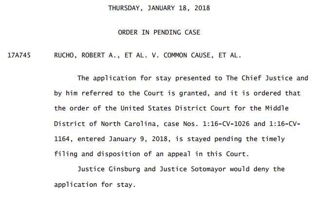
The Supreme Court just issued a Stay of that order.
The application for stay presented to The Chief Justice and by him referred to the Court is granted, and it is ordered that the order of the United States District Court for the Middle District of North Carolina, case Nos. 1:16-CV-1026 and 1:16-CV1164, entered January 9, 2018, is stayed pending the timely filing and disposition of an appeal in this Court.
Justice Ginsburg and Justice Sotomayor would deny the application for stay.
Reuters explains the political significance of the current districts:
The three-judge panel ruled that the Republican-drawn districts violated the U.S. Constitution’s guarantee of equal protection under the law by intentionally hobbling the electoral strength of non-Republican voters. Two of the three judges also said the plan ran afoul of the Constitution’s First Amendment by discriminating based on political belief and association.
Those judges on Tuesday refused to put the ruling on hold.
North Carolina’s congressional maps were challenged in two lawsuits by more than two dozen Democratic voters, the North Carolina Democratic Party and other groups.
Under current North Carolina congressional boundaries, Republicans won 10 of the 13 House districts in 2016, despite getting just 53 percent of the statewide vote.
The Supreme Court is currently examining two other cases from Wisconsin and Maryland involving claims that electoral districts were manipulated to keep the majority party in power in a manner that violated voters’ constitutional rights. That practice is called partisan gerrymandering.
If the Supreme Court were to find partisan gerrymandering unconstitutional, it would be a first:
The Supreme Court has ruled that racial gerrymandering can violate the Constitution. But it has never struck down a voting map as an unconstitutional partisan gerrymander.
Republicans and, in private, many Democrats in North Carolina had expected the Supreme Court to stay last week’s ruling. But elected officials and political strategists had been preparing for the possibility of a hasty redrawing of the congressional map and an upending of carefully laid plans for the midterm campaigns.
Even the brief gap between the trial court’s ruling and the Supreme Court’s order left the state in a fit of paralysis weeks before the deadline to declare candidacies.
 DONATE
Donations tax deductible
to the full extent allowed by law.


Comments
Now THAT is some really UGLY map-drawing…!!!
Deemocrats, wasn’t it…???
Isn’t all gerrymandering ugly? The question is always whether or not it is constitutionally ugly. SCOTUS looks like they’re going to make a ruling on this, as they’ve taken a couple of cases on this point. (The Wisconsin case, frex)
I find it fascinating that no one ever mentions that the modern wave of computerized, data generated redistricting really began in Austin in 1990, with Martin Frost being the chief architect of a map that heavily favored the Dems. Tom Delay and others in the GOP learned that lesson well, and applied it in reverse after the 2000 census. (surviving an attack by the Killer Bees) Everyone else in the country picked up on what was going on in Austin, and we were all off to the races.
that is nothing, look at New York, California, and Illinois for starters. makes this one look down right simple.
Take a look at Maryland http://images.dailykos.com/images/240265/original/Maryland_Congressional_Map_2012.png?1460930569 . Drawn by Democrats explicitly to reduce Republican-leaning congressional districts from 2 to 1 by appending a large chunk of DC suburbs (yes, THAT DC) to the western-most district.
Not really any uglier than the previous D gerrymandered NC maps.
Eastern MD and Western MD used to be solid Republican areas who elected Republican Representatives. I live in Western MD and the Dems were able to successfully gerrymander the West so no Republican can ever be elected there again. They haven’t quite figured out how to gerrymander the eastern shore to ensure no Republicans get elected there yet. Maryland is much worse than NC in the way they’ve carved up the state to ensure the interests of the Democratic Party are first and foremost.
Yes, NC’s Gerrymandering is ENTIRELY Democrats fault.
The craziest districts in the State are the VRA “majority-minority” districts. They exist because of Democrats and they can’t be undone without Democrats suing, and winning, in Federal Court.
Those Districts must remain “majority-minority” and therefore they are minutely drawn to include as many blacks, and as few whites, as possible.
In truth – the ugliest district 12 was drawn to allow for a predominantly African American district. If those areas were dispersed into regular districts there would be no guarantee of a black congressman.
Thought the judges … “said the cases in the other states are different enough legally that their decision could stand no matter how the justices rule.”
Draft of order before final edit, “Justice Ginsberg and Justice Sotomayor would allow a continuation of the Democrat shenanigans.”
I like how it’s Republican-drawn states that are arguably unconstitutional, but Democrat states like Illinois, Maryland, and most of New England are just fine and dandy.
No one in the blue States have the Dark Money to lawfare the Racist gerrymandering done.
Seemed OK when the Democrats in NC did it for 120 years.
Good that we have a SC with constitutional believing members still.
Who says an “independent” re-districting committee will draw fairer districts than state legislatures? I wish both parties would create sensible and competitive districts, but it doesn’t work that way. The GOP finally broke through running on a Democrat-gerrymandered map and captured control of both houses of the NC General Assembly in a census year. They stuck it to the Dems, but the map was no more outrageous than anything passed in the last 100 years other than it favored Republicans over Democrats.
California has already tried that – and in truth, there is no such thing as an “independent” committee anymore, it is not possible. Whoever appoints the members controls the outcome.
Theoretically you could set it up so a computer chose the lines, but then, who would program the computer? And the big ugly bear in the room is that if you DID come up with some independent method of redistricting without gerrymandering, 90% of the CBC lose their seats in the next election.
Because it turns out that impartial redistricting is RACIST!
“Theoretically you could set it up so a computer chose the lines, but then, who would program the computer?”
I believe that within 5 years, advancements in AI and deep learning will allow an actual unbiased district map drawn by computer, one that no one will approve!
They had better watch out – if gerrymandering were declared unconstitutional it would devastate the congressional black caucus…
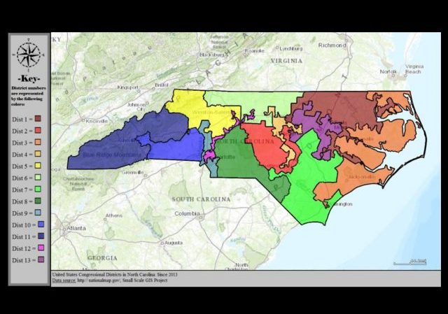
The pictured map is the 2013-2016 map which was deemed unconstitutional because it relied too much on race. The current map is much more sensible (https://en.wikipedia.org/wiki/North_Carolina%27s_congressional_districts) in comparison.
Anything pre-2010 were drawn by democrats. They are particular imaginative.
No matter what you do, partisans will be partisan.
Thank you, EdReynolds. I didn’t think the map posted here looked correct. Commenters who think it looks bad should check out the correct one; it’s pretty decent.
First the Dems sued because the legislature relied “too much” on race, and won. So the legislature made a map that doesn’t use race at all. The Dems sued on this one, too, and the Fourth Circuit, including a Dem partisan judge from NC (Wynn), went along.
As others have said, if the Supreme Court were to rule that a fairly reasonable-looking map which gives partisan advantage is unconstitutional, it would be a new world politically, and how to draw “unbiased” maps is another question. We’ve already had a California lawyer re-draw our state legislative maps. Are distant think tanks going to decide fairly? Who elected them?
The current map that was just ruled against actually looks relatively sane, compared to the one posted.
Why not have about 3000 people roam around the state in direct proportion to the dem,rep vote percentages and when the music stops they grab the nearest seat.