


Texas Panhandle Rocked by a 5.0 Magnitude Earthquake
You know things are getting bad in California when even the earthquakes are moving to Texas.
The Texas Panhandle just got a reminder that the region’s geology is far more restless than many people assume.
A recent earthquake rattled communities across the High Plains this week, drawing attention once again to the buried fault systems that are a little less famous than those I normally cover along the West Coast.
It was one of the strongest earthquakes ever recorded in the Texas Panhandle.
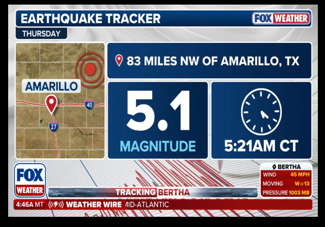
A magnitude 5.0 earthquake struck roughly 24 miles southeast of Miami, Texas, in the state’s Panhandle region at 5:21 a.m. local time Thursday.
The quake’s epicenter was relatively shallow at just 3.42 miles below the surface, according to the USGS.
According to the USGS earthquake catalog, this was the strongest earthquake recorded in the Texas Panhandle and only the fourth magnitude 4.0 or stronger earthquake to strike the region since 1900.
The quake was felt in Amarillo, Texas, as well as Oklahoma City and as far east as Tulsa, Oklahoma.
Geologically, the Texas Panhandle sits in a transition zone where old basement faults can reactivate if the area undergoes new forms of stress.
The U.S. Weather Service’s Amarillo page notes that the Panhandle has a recognized seismic pattern along the Amarillo-Wichita Uplift and Anadarko Basin system. In practical terms, that means the quake is associated with a tectonically old, buried fault system rather than the plate-boundary faults most people think of (especially those associated with the West Coast).
Only three known earthquakes have had magnitudes at or above 5.0. The largest known earthquake in the Texas Panhandle had a Richter Scale magnitude of 5.4 and occurred near Panhandle, TX on 30 July 1925. No known earthquakes in our area have had a magnitude of 6.0 or greater, but there is no guarantee that has never happened since the seismic record is extremely small.
Frohlich and Davis (2002) estimated that an earthquake with a magnitude greater than 6.0 might occur every 300 years in the Texas Panhandle, which could result in serious damage if it occurred near an inhabited location. An earthquake with a magnitude between 5.5 and 6.0 is estimated to occur every 50 to 100 years in the Texas Panhandle.
Most of the earthquakes in the Texas Panhandle occur along the boundary between the Amarillo-Wichita Uplift and the Anadarko Basin system (Figure 2). This area contains subterranean faults extending from just north of Amarillo into southwestern Oklahoma.
Seismologists and geologists suggest that the earthquakes associated with the Amarillo-Wichita Uplift is of concern because it is geologically similar to the Reelfoot Rift (located in northeastern Arkansas), which has produced historic, powerful earthquakes near New Madrid, Missouri. However, this is merely speculation since the largest known earthquake in the Texas Panhandle had a magnitude of 5.4.
You know things are getting bad in California when even the earthquakes are moving to Texas.
THINGS ARE GETTING SO BAD IN CALIFORNIA, EVEN THE EARTHQUAKES ARE MOVING TO TEXAS……The Amarillo-Wichita Uplift (AWU), as noted on this map, was the origin of this week's shaker in Texas. pic.twitter.com/y5EnBL7bHc
— Leslie Eastman ☥ (@Mutnodjmet) July 24, 2026
The epicenter of the quake was a small town near Amarillo.
The epicenter was located about 24 miles southeast of Spearman, a town northeast of Amarillo, USGS reported.
“My cat woke me up. He kind of freaked out about it a little bit and that woke me up,” said Robertson County Judge Mitchell Locke, who serves as emergency management coordinator. “But I did feel it. There was some shaking. Nothing too extreme, though.”
Robertson County is a rural community with a population of about 900 people. As of Thursday morning, Locke said he had not heard reports of any significant damage.
One area of concern is the potential damage to the extensive oil and gas industry in the region.
Donations tax deductible
to the full extent allowed by law.







Comments
“ You know things are getting bad in California when even the earthquakes are moving to Texas.”
🤣🤣🤣
Alright, who’s going to pay for this keyboard? It’s not my fault I spit coffee all over it.
Huh? Isn’t the epicenter the spot on the surface directly above an earthquake’s actual center?
So many earthquakes of late…what does it mean?
It means I’m not the only one that is stressed out lately.
There are no more lately than there have always been.
I am a native Californian born in the 50s now living on the east coast. I have been through many earthquakes in SoCal and NorCal. If something is not larger than 6.0 you really do not feel it and it will not cause damage if not 6.5 or above.
As a geologist explained to me, the hardness of the geological rock determines how easily the quake is felt. Most of CA is hard granite, therefore the quake vibration doesnt travel as far. We had a quake 15 years ago that was only a 2.1 here in Dallas that I felt 20 miles away. The north texas area is a much softer rock (austin chalk) and therefore the quake vibration travels rather freely.
We felt the 6.8 in Seattle in 2001. Definitely.
We also felt the 4.something in Virginia several years back. Something in Virginia bedrock made it travel a long ways.
The first earthquake I felt after moving to CA was a 2.s0mething. I thought it was a streetcar rumbling by. Then I remembered I didn’t live by the streetcar line any more.
You missed the big aspect of this earthquake. The Pantex facility where nuclear weapons are assembled and disassembled sits not too far from Amarillo Texas. Let’s hope an aftershock doesn’t trigger the HE in a warhead being disassembled. I always thought this facility should be underground at the NTS.
not likely to happen, Nuclear weapons need a separate device to be armed.
Actually, it is easy to feel a 4.1 earthquake about 35 miles away, which is our distance from one that happened 12 years ago. On Valentine’s Day 2014 there was an earthquake near Edgefield, SC, that strong (or weak, depending on your perspective). The boom woke us up and there was rattling of items in the house and shaking of the floors. Maybe topography has something to do with the distance at which an earthquake lower on the Richter scale is felt.
Couple years ago RI had a 4.1 I think it was, just off the coast. It shook my house to the point where I got up to see what heavy truck was going by. I learned later it was an earthquake.
I was surprised at the low roar that accompanied it.
As I noted above, the softer the rock, the more easily the quake vibration travels.
The Richter scale reflects the total energy released by the quake. Sometimes a low magnitude (under 4) quake is felt as a sudden jolt that ends quickly if you live close to the epicenter. The scary ones are when the shaking doesn’t stop right away and you start thinking “Is this the big one?”
You will start hearing people claiming it was fracking induced. But, fracking is in hard rock deep below the surface. It does not cause slippages.
However, injection wells where detergents are injected into old oil wells to separate petroleum from water can induce slippages in loose subsurface soils. Tulsa has had hundreds of 2.0 earthquakes triggered from injection wells. (Not Fracked wells.)
With the caveat that I have limited knowledge on the subject, most of the quakes that are alleged to have been caused by swd wells have been in 1.5 to 2.5 richter scale range. A 5.0 scale quake would be unlikely to be caused by a swd well.
The Rocky Mountain Arsenal, just outside of Denver had a waste injection well about 12,000 ft deep. It’s use was discontinued due to just this phenomenon. The small-scale earthquake swarms stopped soon after it’s use was discontinued in February of 1966.
Climate change!
It was a powerful quake, but ground zero was in a rural area—mostly ranch land rather than a populated area—so there was relatively little damage,
In that part of Texas the cows and cactus outnumber people thousands to one.
“According to the USGS earthquake catalog, this [magnitude 5.0] was the strongest earthquake recorded in the Texas Panhandle…”
Yet…
“The largest known earthquake in the Texas Panhandle had a Richter Scale magnitude of 5.4 and occurred near Panhandle, TX on 30 July 1925.”
How can these two be true at the same time?
They cannot. What we have here is a Fox News- Weather summation of whatever feed they get (the first quote) being at odds with the US Weather Service’s report on this quake . The USWS has a lot of data showing seismic history in the region on a page devoted to the Amarillo region. My guess is that the Fox people did not read deep enough into the details before posting their story.