Recent Seismic Events in Washington Lead to Updates to Response Plans for Mt. Adams, Mt. St. Helens
Last week, 2 earthquakes shook the Pacific Northwest….which is just the latest in a string of shakers reported in Washington.
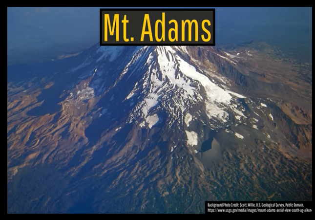
Late last year, I reported that Mount Adams, a volcano in Washington’s Cascade Range that includes the infamous Mt. St. Helens, had recently experienced an unusual increase in seismic activity, triggering a new focus on its study.
In September, six earthquakes with magnitudes ranging from 0.9 to 2.0 were recorded at the site. This number represents a significant uptick compared to the typical rate of one earthquake every 2-3 years and can indicate magma coming to the surface.
However, there has been a lot more shaking going on in that state.
On March 3, a magnitude 4.5 earthquake struck near Orcas Island. This quake was widely felt across the Puget Sound region, including parts of Canada, but caused no damage or injuries. It was the largest earthquake in the region since 2019.
That event occurred after significant seismic activity in February.
KING 5 viewers across western Washington reported being able to feel the earthquake in Oak Harbor, Mukilteo, Bow and Arlington.
Monday’s earthquake comes after a variety of seismic events hit around the region in February, including a pair of earthquakes over 2.5 magnitude on Feb. 27.
PNSN Director Harold Tobin said this shows that Washington is in a seismically active region.
“So far there’s nothing that rises above what I would call normal activity for our region,” Tobin said. “Sometimes we have bigger felt earthquakes. Sometimes we go a longer period without them.”
On March 5, a magnitude 3.9 earthquake occurred near Port Angeles.
Another earthquake shook western Washington on Wednesday, with a nearly 4.0 magnitude quake reported south of Port Angeles.
The 3.9 magnitude earthquake hit the Olympic National Park area around 4:18 p.m., according to the Pacific Northwest Seismic Network.
Specifically, the quake was about 19 miles southeast of Port Angeles.
PRELIM Earthquake: M4.0, 31.1 km SE from Port Angeles, WA at 2025/03/05 16:18 PST https://t.co/yZs7QJ1Xk9
Did You Feel It?: https://t.co/IztueMPF7h pic.twitter.com/ZozMp689Nc— PNSN (@PNSN1) March 6, 2025
With all this activity, emergency officials are beginning to update their response plans in the event of the eruption of Mt. Adams and the infamous Mt. St. Helens.
The precautionary measure includes updating a 2014 plan detailing the communication and information sharing plans between agencies during the event of an eruption at either Mount Adams or Mount St. Helens.
“We don’t really know when it’s going to erupt, what direction, how much ash is going to be, whether it will be days, weeks, months of unrest. So, the best thing we can do on a coordination plan is who has what responsibilities, who shares information, when and at what level, who reports to who,” said Volcano Program Manager Brian Terbush at the Cascades Volcano Observatory in Vancouver.
…The group of leaders will reassess their current plan, which helps describe roles and responsibilities between agencies.
The Washington Military Department shares the new plan will outline actions for preparedness, response, and recovery.
“Coordination is more of a list of roles and responsibilities, while your standard operating procedures are what you do in different situations,” Terbush said. “So, having all of these people in the room, all of these people online, this is a good start.”
While they are at it, they may want to refresh plans for Mt. Ranier.
A review of emergency preparedness for a major earthquake along the Cascadia Subduction Zone is likely, too.
Donations tax deductible
to the full extent allowed by law.


Comments
As a Cincinnatian, Mt. Adams means a completely different place. I used to work on top of Cincinnati’s Mt. Adams, in the Rookwood Pottery building, and while we did once feel an earthquake there, it’s definitely not volcanic.
Love Mt. Adams. The Blind Lemon is one of my favorite bars in the world.
The house I lived in in Olympia, an hour south of Seattle, was substantially damaged in the 2000 Nisqually earthquake. Downtown Olympia, which is largely built on fill, looked like a disaster area. Brick facades had collapsed; they had dogs checking for bodies under the rubble. Fortunately, there were none.
The day after the earthquake, I had a structural engineer come inspect my house. We were on the top floor (it was a split level), and I jumped up and down to test the stability. The engineer’s eyes got wide and she started backing up. We moved out of the house that evening, and didn’t return for about six or eight weeks, after it had been fixed.
Fortunately, I had purchased insurance coverage for damage caused by earthquakes. The policy issued me had a space for a deductible, which was blank, followed by the words “($500 if not filled in)”.
My insurer tried to tell me the policy had a $40,000 deductible, and that the blank space was the result of an error in printing the policy I laughed and told them I was an attorney who sued insurance companies for a living. I paid $500; they paid the balance.
Good times.
That would have been the Rattle In Seattle (a 6.8).
I and my family were in an apartment in Puyallup when it hit. We didn’t have damage from it, but the walls certainly moved more than in our Flinstones house in Guam when earthquakes hit.
Was pierside at PSNS when the quake hit, didn’t feel a thing, was on the smoking sponson wondering why all the emergency generators on the pier were starting, didn’t do any damage to my house.
I was in Bremerton, slow side of 11th. Felt like a huge truck went past the house. Lost some bricks on the chimney.
Why name Port Angeles when it’s closer to Sequim/Blyn? The quake wasn’t 10 miles from here and we didn’t feel a thing. Not much traffic thataway this time of year; access to Upper Dungeness trailhead and the Buckhorn wilderness. I’ll have to check my quake policy, thanks for the heads-up.
Are any of these earthquakes as big as the Rattle In Seattle from 2001?
Question regarding personal response: if there’s an earthquake with an eruption, do you stand in a doorway or not? Specifically an outside doorway? For an earthquake alone, standing in an outside doorframe is recommended. (So, if the building collapses you’re in a more stable pocket, and you’re closer to where people will start digging.) But now you’ve got lava and ash thrown in.
Also, find a concrete wall (or tile) in your place and stash a permanent marker there. That way you can write messages to the anthropologists who will come later and find the cavity where your body used to be. (Think Pompeii.) Plan ahead for posterity’s sake.
(Yes, that last bit is a gruesome joke.)
Ideally, you are outside, away from any structure during an earthquake. So, you’d never stand in an outside doorway. You’d go outside. If you’re in an apartment building, stairways are a decent option. Inside a home, a doorway might be good. Doors should be unlocked, if possible.
Then you definitely get the lava.
Nor Cal has been more active recently, mostly along the general run of the San Andreas fault, Los Angeles region up to Petrolia. Mostly 3 and 4 Richter. Opinions vary between it being a warmup for the “Big One” and a gentle release of stored energy that will prevent a “Big One”.
Since it’s Washington State, I think it’s probable this is simply Satan opening a new gateway into Hell for all his Washingtonian followers.
Like this one? https://thepostmillennial.com/wa-city-council-to-vote-on-rescinding-appointed-trans-councilor-following-onlyfans-cannibalism-fetish-controversy
Clearly, this is a result of climate change. /s
I blame
global warming climate change voter ID weaponized white nationalism Putin First Amendment lax gun laws insurrectionDOGE.