Last Friday MSNBC used an anti-Israel series of maps [Featured Image] frequently spread by “pro-Palestinian” boycott activists. The map sequence purports to show “Palestinian Loss of Land” since 1946.
As we documented in our post, MSNBC uses anti-Israel propaganda map, the maps are a lie both individually and in sequence.
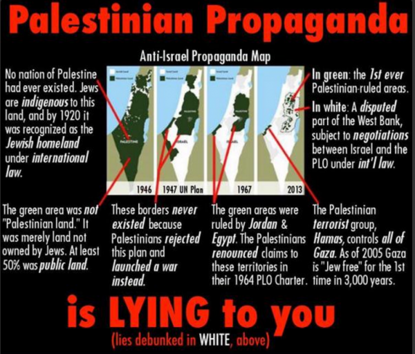
The land in the first map was part of the British Mandate of Palestine, not a country of Palestine, and most of the land on the map was public land, not land owned privately by Palestinian Arabs. The second map, the UN partition plan, was the division of land the Arabs rejected and went to war over. The third map, post Israel Independence, purports to show the West Bank and Gaza as Palestinian, but in fact that land was controlled by Jordan and Egypt, respectively. The last map, showing Palestinian control under the Oslo Accords, represents a gain of land, not loss.
This annotation of the maps has some of the details.
With all that in mind, here’s the original MSNBC broadcast:
Understandably there was a firestorm of controversy over MSNBC’s use of the false propaganda map. Multiple media outlets and people on Twitter pointed out the inaccuracies.
On Monday, MSNBC issued an on-air apology. (partial transcription via Twitchy)
“Last Thursday, in an attempt to talk about the context for the current turmoil in the Middle East, we showed a series of maps of the changing geography in that region. We realized after we went off the air the maps were not factually accurate and we regret using them.”
The apology is far from perfect — as it only dealt with the first map — but welcomed. It shows the function social media can play in countering the never-ending Palestinian propaganda machine which churns out many falsehoods which work their way into the media.
The very people who push such false maps were not happy:
CLICK HERE FOR FULL VERSION OF THIS STORY