The wall-to-wall coverage of Flight 370, despite the relative absence of new information, is not all that surprising. Much of the other news of the day—be it Obamacare, the Crimea takeover and Putin’s anschluss-type designs on other former Soviet satellites, Iran and its nuclear ambitions, or any other of several large stories both worldwide and domestic — are undoubtedly bigger and more important in any objective sense. But once they are covered they are covered, until something new happens.
The Flight 370 saga is different. It’s a true mystery, at least so far, an international one. Although it directly affects fewer than 300 people and their families, that’s a lot of people and we all can identify because nearly all of us fly in planes. That, and its aspect of Twilight-Zoneish unknown, grab people in a very different, and very visceral, way compared to a news story of the more conventional type.
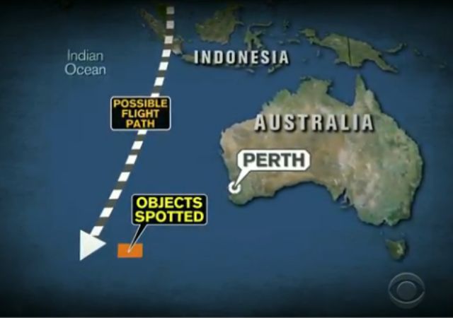
The search for Flight 370 “has exposed the technological limits of satellites” which can see the globe but are not designed to hone in on every section of it equally. Understandably, they concentrate their strongest attention on parts of the world other than the vast stretches of uninhabited ocean.
As for those pieces of supposed debris spotted near Australia:
Via the Washington Post:
“It looks to me like possibly just an exceptionally large patch of sun glint,” said John Amos, president of SkyTruth, which uses satellite imagery to raise awareness of environmental issues. “We’re down in the subtle and ambiguous weeds of human image analysis, where we desperately are trying to find patterns in what we’re seeing.”
Because it takes so long to thoroughly study satellite imagery over a large area, there was a gap between the time the photos were taken and the time it was decided that there might be something special in that area, even though the visual hunt was assisted by many worldwide volunteers scouring the photos.
What’s more, the search for Flight 370 has also exposed the limits of radar. This may be even more disturbing, because radar is an old technology specifically designed (unlike satellite imaging) to detect planes that are where they shouldn’t be. That Flight 370 didn’t trigger more alarms is not a good sign, especially if it flew over land for some part of its rogue journey. Perhaps that was part of the motivation for the flight—to test the limits of radar, for future reference?
[Featured image: CBS News video]
Donations tax deductible
to the full extent allowed by law.


Comments
Have you read this:
http://www.wired.com/autopia/2014/03/mh370-electrical-fire/
Written by someone with great expertise in the field, it appears to be a bit more aligned with Occam’s Razor. As opposed “Perhaps that was part of the motivation for the flight”, that is.
What happened to the cell phones of the passengers during this fire? Where was the SOS? Why did the (co-?) pilot say “good-night” instead of “mayday”?
Occam’s Razor, indeed.
Not too many cell phone towers in the middle of the ocean, usually none. Not all planes have WiFi and it has only been recently that you can use cellphones and WiFi on planes here in the US (unsure of other country policy).
Unlike the US, parts of the world use satellite technology and not towers. Hard to believe that no one on board had the ability to transmit something.
Also, it went over a lot of land masses, where cell phones would be usable.
I think that was why the plane immediately shot up to 45,000 feet – to incapacitate those on board and prevent contacts. After that, whoever did this was in control.
Valerie,
As AGrimm points out the lack of cell phone calls has been debunked as an issue since just about day one.
The lack of a May-Day call can be explained by a fast, turbulent fire taking place after the “good night” comment.
Malaysian Airlines finally admitted carrying a dangerous cargo. Lithium-ion batteries have caused 140 air fire incidents in the last 20 years. L-I batts burn hot and fast and in the cargo hold would be in close proximity to avionics control system wiring. Such air cargoes have caused two cargo plane crashes one as recently as 4 yrs ago.
Fire isn’t looking so stupid now.
Wretchard over at PJMedia summarizes the potential problems with the Wired theory:
Except that radar now works differently. Before (active) radar sent a signal that was bounced back. Some active radar are still around but it’s mostly passive. The (passive) radar detects a signal from a transponder on the plane. If the transponder goes off the plane goes dark.
Nowadays most of the active radar in place is used in regions of potential high military activities.
According to news reports the Malaysian military radar showing the plane on the westerly path, in the Straits of Malacca, was active radar.
I was just replying to the comment about the limits of radar. It’s kind of hard to point out the limits when it isn’t available ( mostly ).
Transponders. Remember 9/11, they couldn’t find the planes because, as the controllers complained, they shut off the transponders. You would think they might have noticed this was a problem?
If Putin decides to bomb the US, he will send planes and shut off the transponders. We will file a complaint with the FAA? (too late).
The Last Refuge/TCTH are having a field day with this. Unfortunately some are starting to sound as wacky as global warming alarmists.
The wackiest theory is that the plane was hijacked to Pakistan to be used in a teror operation. The US found it, killed the terrorists and are now spreading the debris around Oz, and reprogramming the black boxes to plant near Oz too. This to prevent embarrassment to the Pakistani government.
After 9/11 I can buy the terrorist plot but not the coverup.
Pity those of us who have to live among the conspiratorial-ists.
That is a massive & remote are but Australia does rescues & surveillance sorties there regularly .& have wgorked with the less than stellar imaging before. There has been some bad weather & if they can’t getto those floating pieces , we may never know.
They at least are someone who can be trusted to say Aye or Nay unlike most other players .
It is interesting that the ocean debris was cited using DataGlobe’s satellite imagery that had been ““crowdsourced” by some 3 million viewers only to have the Australian Prime Minister pretending that his country had found new evidence.
But the winds and currents in the Malacca Strait never cease in the these latitudes between 40 and 50 degrees. The weather is so bad that the oceans down there are referred to as the Roaring Forties.
Most suspect there are sensitive military implications & sources are not disclosed.
Crowdsourcing is interesting but it cannot summon up an air force / navy to get physical. The Band of internet Citizenry has its limits.
Several British newspapers have depicted the arc as a flight path, as they did in the graphic in this story. It is not. It is a circular line of position of where the plane was at precisely 8:11am Malaysian time, not a flight path. Unfortunately the circular LOP was reported as a corridor leading many assume it was a flight path.
When the engine data was transmitted to the Inmarsat satellite, it also reported the elevation angle of the antenna on the plane as it locked on to the satellite. By computing this angle backwards from the satellite, you get this LOP. It is much like the LOP one gets from a sextant reading of the moon or a star in celestial navigation.
What hasn’t been reported is that by using the hourly reports you can deduce whether the plane was going parallel to the LOP or perpendicular. If the circular LOP expands 450nm in the next hour, the plane is flying perpendicular, outwards. And the reverse is true if the circular LOP contracts. Rough calculations can be deduced for shallower angles. What these calculations can’t do is tell whether the plane was flying north or south. This is ambiguity is what the north south “mirror images” referred to in earlier reports.
My guess is our intelligence folks have the north south mystery solved pretty much. If the calculations show the plane avoiding coastal areas in the north route hypothesis, then there is a high probability that is the course taken. If the projections show the plane flying over the central Indian land mass with all of the radars, there is high probability the southern route was taken.
The Malaysian authorities have mentioned they have military radar information from other countries, but they are tight lipped over what it shows.
I’m going with Boeing…and Rolls Royce. (and they are more on the side of the alleged conspiracy theorists at The Last Refuge and with General McInerney and his sources, than the fire in the cockpit folks)
http://pjmedia.com/tatler/2014/03/21/chambliss-boeing-says-no-way-would-catastrophic-event-turn-off-transponder/
Boeing says their OnStar connections place the plane in Pakistan, near Iran.
BTW – Iran is building a mock-up US Aircraft Carrier.
Islam is truly a form of institutional conditioned cognitive distortion and sociopathology.