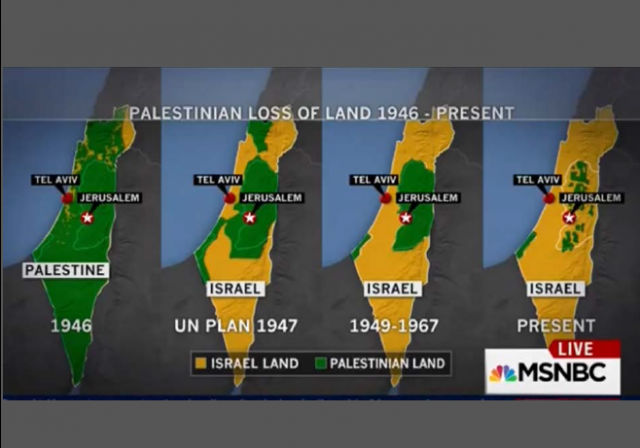
MSNBC uses anti-Israel propaganda map (Update: Admits error)

There is a standard fixture at anti-Israel BDS rallies and events — a map purporting to show loss of Palestinian land to Israel.
But it’s a completely misleading and false map.
Yet MSNBC used it on air today — a demonstration of how Big Lies become truth when repeated often enough:
The map has been debunked so many times in the past, a simple Google search would have demonstrated the problem.
Elder of Ziyon blog has written a definitive taken down of the map in 2012, The Map That Lies. The Tower magazine has an exhaustive research post on why the map is a lie, The Mendacious Maps of Palestinian “Loss”. Even The Economist had an explanation why the map was deceptive in 2010, when blogger Andrew Sullivan used the map.
Most important is that Map 1, which purports to show “Palestinian land” as comprising most of the British Mandate (after Britain already has lopped off most of the Mandate land to create Jordan) does not show “Palestinian” land at all. As Elder of Ziyon explained, that land was mostly public land, and there was no country of Palestine:
While I presume that the white sections are indeed the land that was privately owned by Jews, the land in green was not privately owned by Arabs.Only a tiny percentage of land in Palestine was privately owned. The various categories of land ownership included:
- Mulk: privately owned in the Western sense.
- Miri: Land owned by the government (originally the Ottoman crown) and suitable for agricultural use. Individuals could purchase a deed to cultivate this land and pay a tithe to the government. Ownership could be transferred only with the approval of the state. Miri rights could be transferred to heirs, and the land could be sub-let to tenants. If the owner died without an heir or the land was not cultivated for three years, the land would revert to the state.
- Mahlul: Uncultivated Miri lands that would revert to the state, in theory after three years.
- Mawat (or Mewat): So-called “dead”, unreclaimed land. It constituted about 50 to 60% of the land in Palestine. It belonged to the government. …If the land had been cultivated with permission, it would be registered, at least under the Mandate, free of charge.
By the early 1940s Jews owned about one third of Mulk land in Palestine and Arabs about two-thirds. The vast majority of the total land, however, belonged to the government, meaning that when the state of Israel was established, it became legally Israel’s. (I believe that about 77% of the land was owned by the government, assuming 6 million dunams of private land as shown in this invaluable webpage on the topic from which I got much of this information.)To say that the green areas were “Palestinian” land is simply a lie.In the case of this version of the map, the lie is even worse, as the implication is that pre-1948 Palestine was an entirely Arab country with no Jews and no Jewish land ownership. Of course, before 1948 the word “Palestinian” more often than not referred to Palestinian Jews, not Palestinian Arabs. For example, the Palestine exhibit at the 1939 World’s Fair was entirely Jewish, the Palestine Orchestra was entirely Jewish, the Palestine soccer team was almost entirely Jewish, and so forth.
After the internet exploded after MSNBC used the map, Elder of Ziyon took to Twitter to repeat again why the map is a lie:
In total, the map is a total deception a propaganda device adopted by a supposed “Middle East Expert” and a major U.S. news network.
This map from The Tower article demonstrates a more realistic history — until the Oslo Accords Palestinian Arabs had ZERO politicital control over anything:
There is another map MSNBC could have shown, it’s the map that show how much land Israeli has given up for peace — but has not received peace (via Elder of Ziyon):
This annotation of the Map That Lies also is good (not sure who created it):
UPDATE 10-18-2015: – Via Elder of Ziyon, Fletcher has sort of partially apologized:
Obviously, that apology is inadequate. Substantively, it only addresses the first map, and misses the point that the whole sequence and purpose of the maps is based on a false premise that Palestinian Arabs “lost land” when in fact never before the Oslo Accords did they control any land. Also, a comment on a Facebook post is hardly the proper forum — MSNBC and Fletcher need to publicly acknowledge and correct their error.
and a further update, via The Free Beacon, MSNBC Admits Anti-Israel Graphics Were ‘Wrong’:
“In an attempt to shed light on the geographic context of the Israeli-Palestinian issue, we aired a map that was factually wrong,” the spokesperson said on Sunday.Two MSNBC broadcasters, Kate Snow and Martin Fletcher, “will address the map in a segment Monday about agendas and disinformation on both sides of the Israeli-Palestinian conflict,” the spokesperson said.Fletcher, a Middle East analyst, said on Sunday that the map and analyses were “dead wrong.”
CLICK HERE FOR FULL VERSION OF THIS STORY